NOTOXYTECHTECHNOLOGIES PVT LTD

Ground control station

Notoxytech GCS Pilot — Windows

GCS-WP · Universal ground control station on a Windows laptop, flown with a gamepad

A universal ground control station for drones and other MAVLink vehicles (ArduPilot and PX4) on a Windows 10 / 11 laptop — flown with a USB or Bluetooth gamepad, the screen and the keyboard.

Function catalogue · PDF, 0.7 MB · User manual, PDF, 6.4 MB

1 / 4
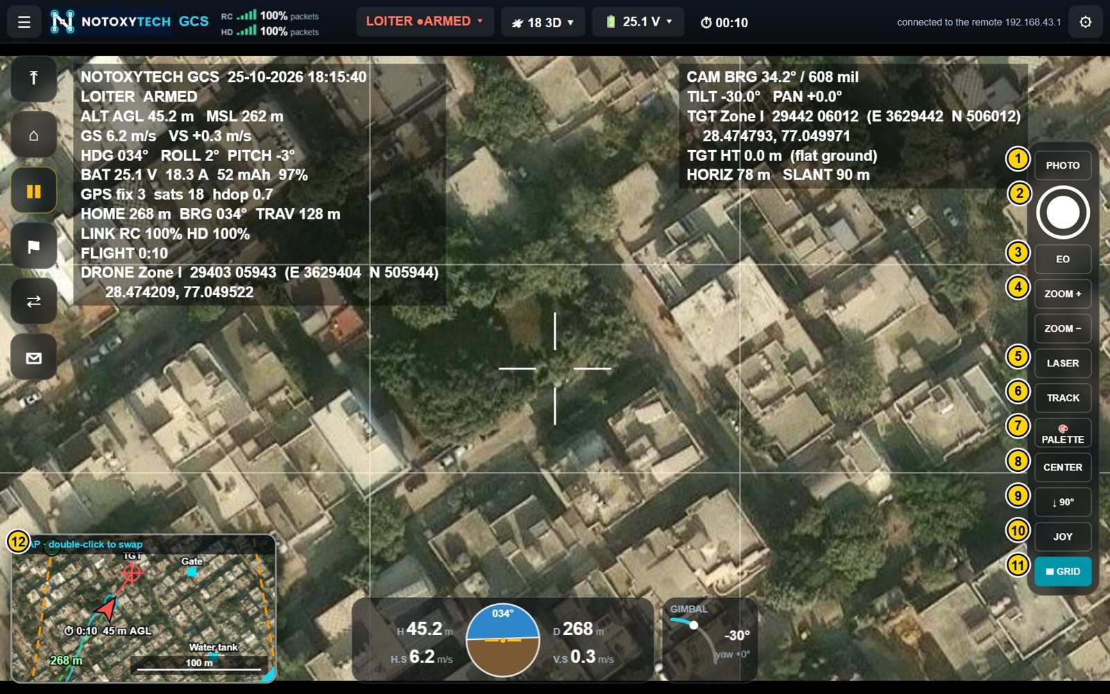
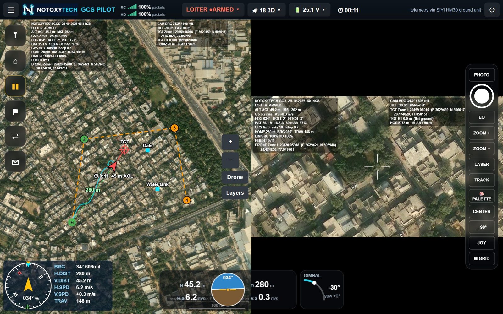
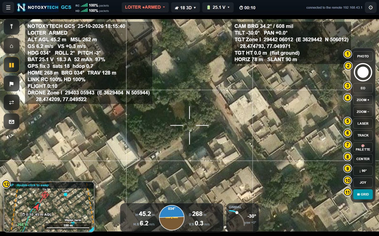
Map and live video side by side on the laptop
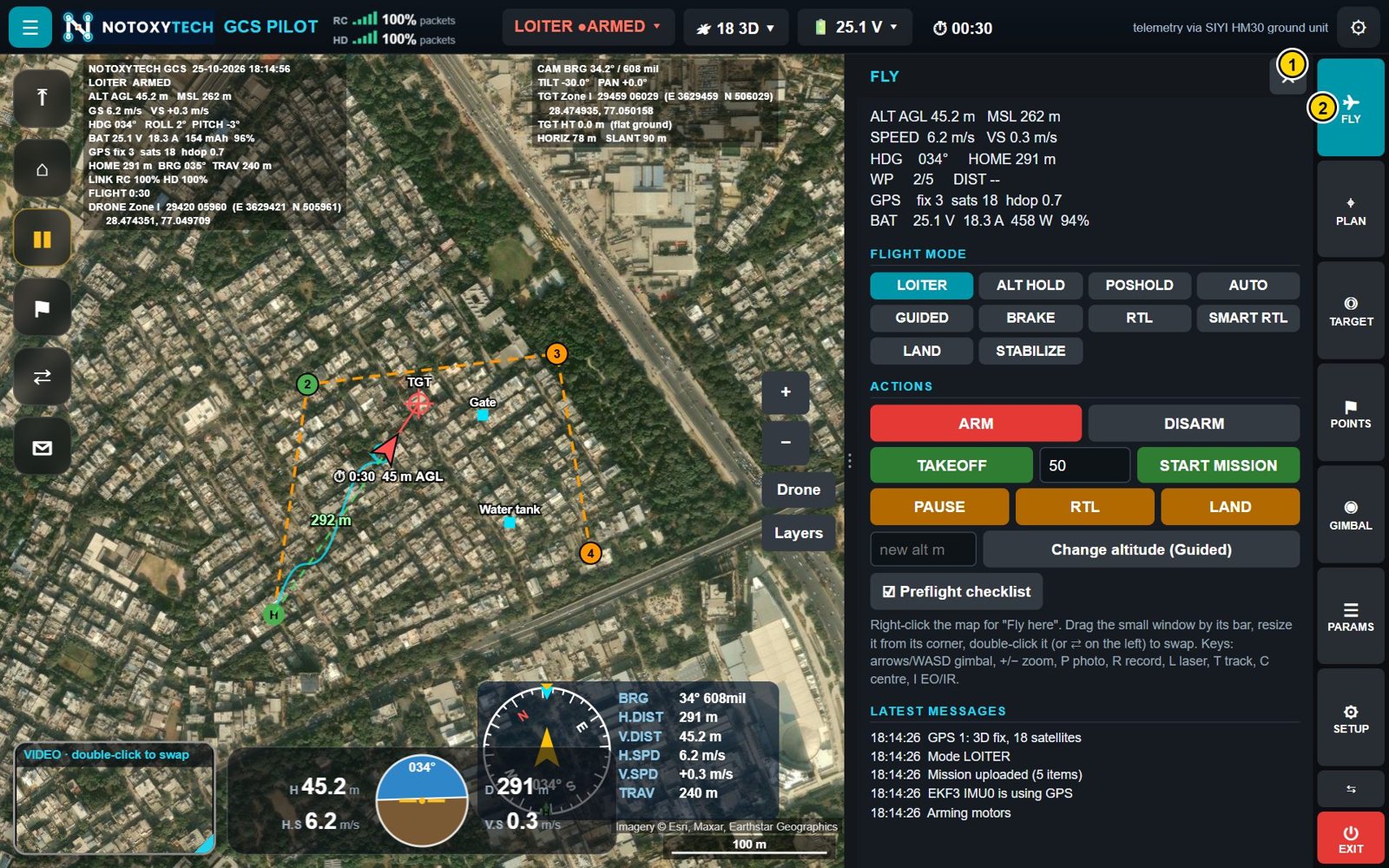
FLY tab: flight modes, take-off, land and return home
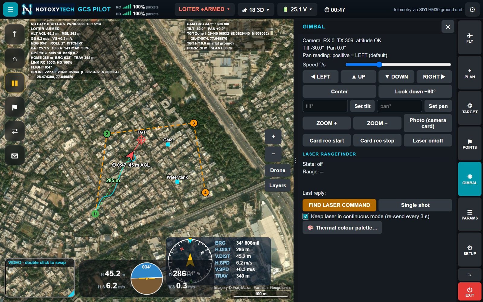
Gimbal and laser rangefinder controls
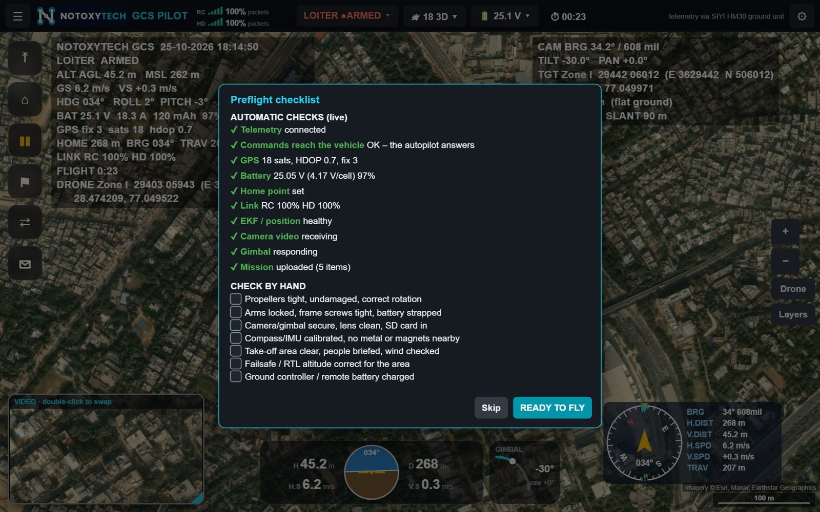
Preflight checklist: automatic and hand checks

Overview

One app for every MAVLink UAV

Notoxytech GCS Pilot for Windows shows flight data, the map and the camera picture on one screen, and controls the vehicle, the gimbal camera and the laser rangefinder.

It runs in Microsoft Edge or Chrome on a Windows 10 / 11 laptop and connects to the drone directly: a SIYI HM30 ground unit over Wi-Fi or Ethernet, a RadioMaster Ranger / Nomad (ExpressLRS, USB or Wi-Fi), or a telemetry radio on USB.

There is no remote controller in the loop — the vehicle is flown with an Xbox, PlayStation or generic gamepad, with automatic return home 3 seconds after the gamepad is lost.

What it does

01

One screen

Flight data, the map and the camera picture together, with instruments and quick flight buttons.

02

Universal MAVLink

Works with ArduPilot (Copter, Plane, QuadPlane / VTOL, Rover, Sub) and PX4 vehicles.

03

Gimbal and laser control

Aim, zoom, switch day / thermal, track a target and fire the laser rangefinder.

04

Targeting and fire correction

Target position by laser or flat-ground calculation, captured points, add / drop and left / right corrections.

05

Indian grid formats

Lat/Long, UTM, MGRS, Indian Grid (Everest) and DSM (India NSF LCC) coordinates.

06

Offline maps

Download named map areas and fly without an internet connection.

Specification

PLATFORM

Runs on
Windows 10 / 11 laptop, with Microsoft Edge or Chrome
Connects to the drone
SIYI HM30 ground unit (Wi-Fi / Ethernet), RadioMaster Ranger / Nomad (ExpressLRS, USB or Wi-Fi), telemetry radio on USB
Flown with
USB or Bluetooth gamepad (Xbox, PlayStation, generic), screen and keyboard

SUPPORTED HARDWARE

Autopilots
ArduPilot (Copter, Plane, QuadPlane / VTOL, Rover, Sub), PX4
Radio links
SIYI HM30 and MK-series ground units, ExpressLRS (RadioMaster Ranger / Nomad) in MAVLink mode, SiK telemetry radios, Herelink, any MAVLink UDP / TCP / USB link
Gimbal cameras
Skydroid C11, C12, C14; SIYI A8 mini, A2 mini, ZR10, ZR30, ZT30, ZT6; Reebot UniPod MT11; any MAVLink gimbal through the flight controller
Video
H.264 and H.265 over RTSP or MPEG-TS, low delay
Gamepads
Xbox, PlayStation, PS2 adapters, generic USB / Bluetooth

FLIGHT CONTROL

Take off
Arms and climbs to a chosen height (multicopter, VTOL; planes in TAKEOFF mode)
Land / return home / pause
Land where it is; fly home and land; stop and hold position
Flight modes
All modes of the vehicle type (LOITER, POSHOLD, GUIDED, AUTO, RTL, SMART RTL, BRAKE, LAND …)
Arm / disarm
With confirmation; warning when the vehicle seems airborne
Fly here
Sends the vehicle to a point on the map at a chosen height (GUIDED)
Change altitude
Climbs or descends where it is
Gamepad flying
Sticks as RC override, 25 times a second; camera on buttons; automatic return home 3 s after the gamepad is lost

MAP AND MISSIONS

Live map
Vehicle, home, flown path, line to home with distance, camera target, waypoints and saved points
Map sources
Google, Bing, Esri, OpenStreetMap / OpenTopoMap, Mapbox, custom; satellite, hybrid, street, terrain
Offline maps
Download named areas for flying without internet
Mission planning
Waypoints by tap or typed coordinates; take-off, loiter, loiter turns, speed, RTL, land; edit, move, reorder
Survey area
Zig-zag lines over a drawn area with spacing, angle, height and overshoot
Upload / download / start
Sends the mission, reads it back, starts it in AUTO
Mission files
Save and load; Mission Planner / QGroundControl .waypoints

CAMERA, GIMBAL AND VIDEO

Live video
Low-delay camera picture with OSD; map and video swap, split or picture-in-picture
Photo and recording
Photos and MP4 recordings with the OSD burned in; recording on the camera card
Day / thermal
Switch EO / IR; thermal colour palettes
Zoom
Hold to zoom in or out
Aiming
On-screen joystick, buttons, exact tilt / pan angles, centre, look down, keyboard
Target tracking
Camera follows a target chosen by tap or box
Laser rangefinder
On / off, single shot, continuous; distance on the picture
Grid lines
Nine-box framing grid on the live picture only

TARGETING AND COORDINATES

Target position
Position, height and distance of the point under the crosshair, by laser or flat-ground calculation
Capture points
Save the target or the vehicle position with a name
Fire correction
Left / right and add / drop corrections from falls of shot, also in grid east / north
Deviation
Distance and direction between points
Coordinate formats
Lat/Long (decimal, D M S), UTM, MGRS, Indian Grid (Everest, zones I–IVa), DSM (India NSF LCC, 18 sectors, automatic)
Export
Points as CSV (Excel) and KML (Google Earth)

SAFETY AND MONITORING

Preflight checklist
Live automatic checks plus hand checks; at start-up and on demand
Link quality
Both directions of the link, per link type, with a 2-minute graph
Battery
Voltage, current, capacity used, percentage, reserve warning
Messages
Autopilot messages, errors and warnings
Voice
Spoken warnings and status (if enabled by the manufacturer)
Instruments
Height, speeds, distance, artificial horizon, compass, camera tilt

RECORDING AND FILES

Photos and videos
Pictures\NotoxytechGCS and Videos\NotoxytechGCS on the laptop
Points and plans
CSV, KML and .waypoints files

What you get

  • Notoxytech GCS Pilot for Windows
  • User manual and function catalogue (PDF)

The OEM functions (autopilot parameters, sensor calibration, link, camera, gimbal and display setup) are password-protected and reserved for the manufacturer of the drone system.